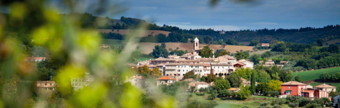
Stands among the hills to the left of the Lower Metauro Valley, 2.5 km from Tavernelle, which lies along the ancient Flaminian Way, 16.4 km from Fano (in Roman times there was a “tabernula” or “statio” at Tavernelle, where travellers could stop and eat).
Serrungarina was originally known as Brisighella but probably took its present name from Ser Ungaro degli Atti, a lawyer who lived there during the 14th Century. The town formed part of the lands of Galeotto Malatesta, who built a castle there in 1341, of which nothing remains except for a water tank. It was there that Sigismondo Malatesta defeated the troops that Vitelleschi had sent against Pope Eugene IV in 1432. For a long period after that, Serrungarina became a cornerstone in Fano’s defences against the Montefeltros. In 1482, the people of Fano built an underground channel (called ‘La Traforata’) at their own expense, with a vast well with a spiral access ramp, in order to carry water to the ancient mills at Sacca.
Inside the town walls, at the top of a pleasant stairway, stands the parish church of Sant’Antonio abate. It was built on the site of the old castle in 1665, and rebuilt in 1867. Inside are two fine paintings by Giuliano Persciutti of Fano (‘The Immaculate Conception’) and Gianfrancesco Guerrieri of Fossombrone (‘The Visitation’).
The ancient walled villages of Bargni and Pozzuolo now form part of the district of Serrungarina. Villa Federici (known also as Villa dei Pini) stands close to the first of these villages. It was built by Abbot Domenico Federici in 1683 and is now a hotel. Near to Pozzuolo is Monte della Màtera (393 m), about which many legends have grown over the centuries.
Questo sito utilizza i cookie per migliorare la tua esperienza. Accetta questa condizione per continuare la navigazione. AcceptLeggi
Privacy & Cookies Policy
Privacy Overview
This website uses cookies to improve your experience while you navigate through the website. Out of these, the cookies that are categorized as necessary are stored on your browser as they are essential for the working of basic functionalities of the website. We also use third-party cookies that help us analyze and understand how you use this website. These cookies will be stored in your browser only with your consent. You also have the option to opt-out of these cookies. But opting out of some of these cookies may affect your browsing experience.
Necessary cookies are absolutely essential for the website to function properly. This category only includes cookies that ensures basic functionalities and security features of the website. These cookies do not store any personal information.
Any cookies that may not be particularly necessary for the website to function and is used specifically to collect user personal data via analytics, ads, other embedded contents are termed as non-necessary cookies. It is mandatory to procure user consent prior to running these cookies on your website.